High-quality 2D and 3D maps and models start with high-quality source imagery and good flight planning. We've put together this list of recommendations and suggestions below to help you get set up to collect great data!
These guidelines are the result of the combined experience of our team of experts plus observations and feedback we've received over the years from our customers. If you have any questions or suggestions of your own, please let us know by sending us an email at support@skycatch.com.
Standard Datasets:
Camera Recommendations
- Recommended camera configuration.
- ISO from 80 to 400
- Exposure time = 1/1000
- Shutter speed time = 1/1002
- Camera pointed directly towards the ground (straight down, aka nadir)
Avoid using lenses that result in distortion (e.g. fisheye) and ISO > 400.
Photo Recommendations
- Remove blurry images, photos captured on takeoff/landing, and photos captured traveling to/from the flight area
- If oblique imagery is included, it must have at least 80% overlap on every side (top, bottom, left, right) and the object of interest should be centered in each photo. Avoid capturing the horizon or sky as that will affect your photogrammetry results
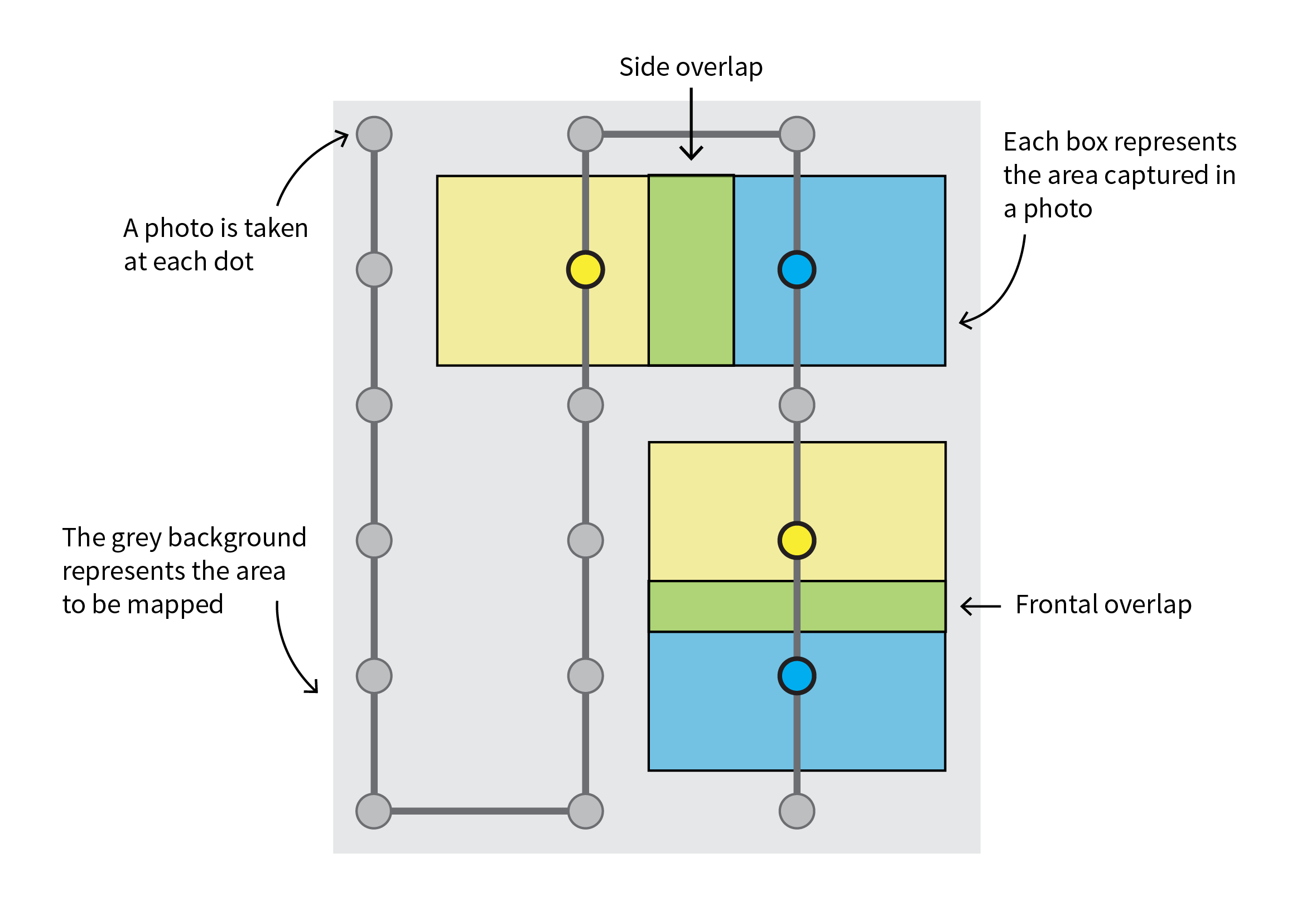
Mission Planning and Terrain Recommendations
- The mission planning phase should ensure that your photos have a side overlap of>60% and image front overlap of>80%. We recommend using a mission planner such as the Skycatch flight app if you have a compatible DJI drone!
- Ground Surface Composition
- Area with a high level of ground features (non-uniform surface colors that contain patterns and textures)
- Less than 25% of the total surface area contains “uniform surfaces” such as snow, water, forest, bright/highly reflective materials (such as solar panels or glass)
- Time of day and lighting conditions
- Flying within one hour before and afternoon (or peak sun) provides optimal lighting conditions with the least amount of shadows.
- If multiple flights are required for a large site, avoid extreme variations in lighting and shadows by performing flights in similar lighting conditions.
- If the collection area is very large, take note if there is inconsistent cloud cover over time. Large variance in cloud conditions can cause the photos to have a large variance in light level, which can cause the stitching to fail and accuracy to suffer. If you encounter this situation, we recommend using pre-processing software such as Lightroom, to even out the brightness and contrast across all photos before uploading to Skycatch.
- Flights should be flown at a consistent altitude above ground level (AGL). For collection areas with changing ground elevation (hilly or mountainous), use terrain-following.
- If multiple flights are needed for a dataset:
- The footprint of photos from each flight must maintain the minimum overlap requirements (listed above)
- The flights should occur within the same general period to avoid large changes in lighting conditions
Guidance for datasets that are processed with GCPs:
- When using the Printable Skycatch Control Points (GCPs or Checkpoints), please follow these guidelines to get the best conditions for successful processing every time:
- When flying 40 meters AGL to 120 meters AGL, print GCPs to at least 116 cm x 116 cm (46" x 46"). Do not fly higher than 120 meters AGL, as the GCPs will be too small to detect.
- When flying lower than 40 meters AGL, you can print the GCPs to 61 cm x 61 cm (24" x 24").
- Ensure you have accurately surveyed the GCP at the exact center point.
- Ensure the GCPs are evenly distributed across the entire site, spaced no more than 200 meters apart (218 yards).
- Ensure that the drone’s camera has a clear, unobstructed view of all control points. Do not place them where they will be blocked by a tree, tower, or crane.
- Control points file should be correctly formatted and filled in with the format as described in the Skycatch Support Center here.
- The control points coordinate system your control points are submitted in must be a known coordinate system and not an arbitrary system. You can verify your coordinate system in the EPSG.io database.
- Note: There are two types of control points: ground control points and checkpoints. Checkpoints are currently only used for verification purposes if the user reports an issue with the accuracy of their dataset, so you will not automatically receive an accuracy report if you choose to upload control points with a dataset.
Comments